Where the Water Waits: Mapping Permeability Across the School Grounds
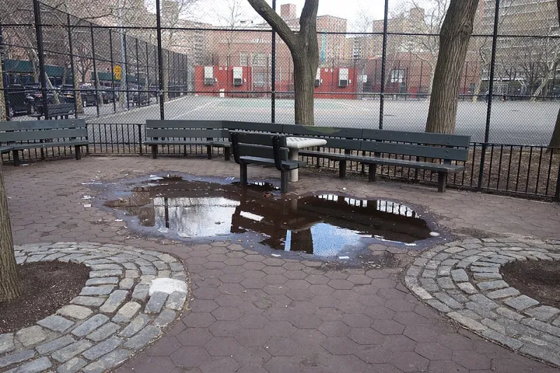
Photo: Tdorante10, CC BY-SA 4.0, via Wikimedia Commons
Every autumn, the same corners of the school grounds collect water. Between the sports hall and the bike shelter, along the lower edge of the top field, and in the dip beside the kitchen entrance, puddles reappear within hours of heavy rain and linger for days afterwards. For years these were simply inconveniences to be walked around. This term, a group of Key Stage 3 pupils decided they were evidence waiting to be collected.
Why a puddle is data
A puddle is not a random event. It marks a place where the rate at which rain arrives exceeds the rate at which the ground beneath can accept it. That imbalance can arise for several reasons: the surface may be sealed, as with tarmac or paving; the soil may be compacted by foot traffic; the subsoil may be heavy clay that drains slowly; or the ground may simply be low-lying, so water gathers from a wider area. Distinguishing between these explanations is the difference between complaining about a puddle and understanding one.
The project began with a question that was deliberately modest: where does water stand on our site, and for how long? Rather than attempting a full hydrological survey, the pupils set out to produce a repeatable map — a record that could be compared, week on week, and handed on to next year's cohort.
Designing the survey
The team identified twelve monitoring points across the grounds, chosen to represent a range of surfaces: tarmac playground, block paving, a grass verge, bare soil beneath the trees, a bark-mulch bed, and the compacted earth of the field gateway. Each point was marked discreetly with a wooden peg so that readings could be taken from the same spot each time.
Measurements were taken after rainfall events of at least four millimetres, using a simple protocol. Pupils recorded the depth of standing water at its deepest point with a steel rule, the approximate extent of the wet patch using a tape measure, and the time taken for the water to disappear entirely — checked at the same time each morning until the surface was clear. Observations were logged alongside air temperature, the volume of recent rainfall taken from the school's rain gauge, and notes on ground conditions such as fallen leaves or recent deliveries to the kitchen entrance.
The most instructive part of the methodology was the infiltration test. A short length of plastic pipe, open at both ends, was pressed firmly into the ground and filled with a measured volume of water. The time taken for that water to soak away gives a rough comparative measure of how readily each surface accepts water — not an absolute permeability figure, but a fair basis for ranking one location against another.
What the grounds told us
The results were, in the pupils' own words, 'mostly unsurprising and occasionally not'. The tarmac and block paving shed essentially all of the water landing on them; ponding was shallow but persistent at the edges, where the camber directs runoff towards joints and gullies. The grass verge absorbed moderate volumes within minutes. The compacted field gateway, by contrast, behaved almost like a sealed surface: an infiltration test that drained in under two minutes on the verge took over twenty at the gateway.
The genuinely unexpected finding concerned a bark-mulch bed that had been assumed to be highly absorbent. It took water slowly, and pupils traced the cause to a compacted layer a few centimetres below the surface — the legacy, staff confirmed, of a delivery route used during building works two years earlier. That single observation did more to explain the localised flooding outside the science block than any amount of speculation had achieved.
Equally important was what the pupils declined to claim. With twelve points and a single autumn of readings, the survey cannot describe drainage across the whole site, nor can it predict how the grounds will behave in an exceptional storm. It is a set of indicative observations, and it is presented as such.
The family version: a tin, a ruler and ten minutes
The same principles can be explored on a walk to school or in a back garden, with no specialist equipment. A clean tin with both ends removed, pressed into bare soil until it sits a couple of centimetres deep, makes a serviceable infiltration ring. Pour in a measured amount of water — 250 millilitres is ample — and time how long it takes to disappear. Repeat on a lawn, a flower bed and a patch of bare earth, and compare.
Alongside the timing test, families can keep a simple wet-weather log: photograph the same few spots after each substantial rainfall, note how long water remains, and record whether the surface is paved, grassed or bare. A fortnight of observations is enough to reveal patterns — and to raise better questions than the ones you started with. Is the puddle always in the same place? Does it clear faster after a windy day? Does the water appear to be arriving from somewhere uphill?
Reading the results without over-reading them
A word of caution belongs here. A single reading proves very little. Soil that has been dry for a fortnight will absorb water differently from soil saturated by a week of rain; temperature, leaf fall and foot traffic all exert an influence. Reliable conclusions require repeated measurements under comparable conditions, and honesty about what has been controlled and what has not. This is precisely the discipline the pupils have practised, and it is the habit of mind that distinguishes a scientific observation from an anecdote.
Keeping it safe
Any outdoor water investigation carries straightforward risks that are easy to manage. Pupils worked in pairs, wore gloves when handling soil, and washed hands thoroughly afterwards. Nobody lifted drain covers or reached into gullies. Stagnant water was treated as something to measure from a distance, not to play in. Families repeating the activity should avoid roadside verges and any water that could be deeper than it appears, and should keep well clear of moving water after storms. In cold weather, ice over standing water should be avoided entirely.
What happens next
The puddle map will be redrawn in the spring, giving the team a second dataset for comparison. A summary has been passed to the site team, not as a demand for action but as a contribution of evidence — and the pupils have proposed a follow-up study of the gully positions and the fall of the land around the science block. Whether or not any drainage work follows, the project has already achieved something worthwhile: a muddy corner of the school grounds is now understood as a small, legible system, and the pupils who measured it have learned that careful observation is rarely wasted.